
Tracking technology has become part of everyday life. People use it to find lost keys, check delivery progress, protect vehicles, and manage equipment. Yet the different devices behind these tasks do not all work in the same way.
The term Tracqueur appears in online discussions about location tracking. It may suggest a GPS tracker, a Bluetooth tag, or a digital monitoring tool. However, it is not the established technical name for one specific product or system.
Understanding how trackers find and share locations can help you choose the right option. A useful device should fit the environment where you actually plan to use it. It also makes it easier to recognize their limits and protect personal information.
What Does Tracqueur Mean?
Tracqueur is an informal spelling seen online in connection with tracking. It resembles the French word traqueur, which traditionally means a person who pursues or tracks something. The exact spelling matters because similar words can describe different things.
In French, traceur is commonly used for a device that follows the location of an object or vehicle. The word can also describe a digital tracking element, depending on context. Neither meaning makes Tracqueur a universal product name.
For this guide, Tracqueur refers broadly to modern tools that help identify, record, or report locations. Such tools can be physical tags, vehicle units, smartphone applications, or connected business systems.
Before using a service with this name, check what it actually offers. A name alone does not establish whether a product is genuine, reliable, or safe. Its description should explain the tracking method, supported devices, data practices, and any costs rather than relying on a familiar-sounding label.
How Modern Tracking Technology Works
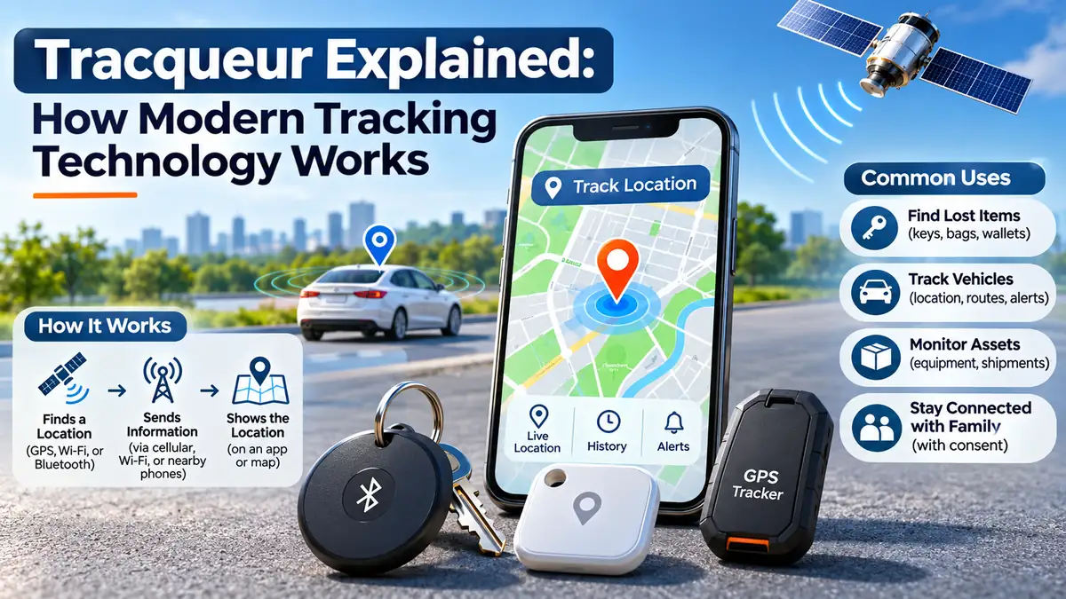
A typical location-tracking system has three jobs: determine a position, communicate useful information, and display the result. The device may complete these tasks itself or depend on other equipment nearby.
First, a tracker estimates where it is. It might receive satellite signals, detect nearby wireless networks, or broadcast a Bluetooth signal that another device can recognize. These methods produce different levels of detail.
Next, the information reaches an app or online service. Some trackers send updates over a cellular network. Others depend on a nearby phone to report where their signal was detected.
Finally, software places the available position on a map or records it in a history. Updates are not always continuous. The reporting interval may be fixed by the manufacturer or adjusted in an app. A map may show the last reported location rather than where an item is at that exact moment.
GPS and Satellite Positioning
GPS stands for Global Positioning System. Satellites transmit precise time and position information, and a receiver measures those signals to calculate its location. Typically, signals from at least four satellites are needed for a full position fix.
GPS receivers listen to satellite broadcasts; they do not normally send their location back to the satellites. A separate connection is needed when someone wants to view a tracker remotely on a phone or computer.
Modern devices may also use other satellite-navigation systems, including Galileo, GLONASS, and BeiDou. Support for several systems can improve availability, especially where buildings or landscape features partly block the sky. Even then, indoor tracking remains difficult without additional signals.
Bluetooth Trackers and Nearby Item Finding
Bluetooth trackers are small tags designed mainly for everyday belongings. They broadcast short-range signals that a compatible phone can detect. They are useful for keys, bags, wallets, and similar items.
If a tag is within range, its app may show that it is nearby or make it play a sound. Some models support more precise finding with additional wireless technology, but that feature depends on the phone and tag.
When a tag is far away, certain finding networks use participating phones to detect it. Those phones can securely report the approximate detection location, allowing the owner to see where it was last noticed.
This is different from a self-contained GPS tracker. Nearby finding can also vary by phone model, operating system, and supported features. A Bluetooth tag generally cannot calculate its own satellite position, and remote updates depend on compatible devices passing nearby.
Cellular, Wi-Fi, and Other Connections
A vehicle or asset tracker often uses GPS to calculate position and a cellular network to send updates. The device may require a SIM, an eSIM, and a paid data plan. Coverage is important for live monitoring. An international trip may also involve roaming restrictions or additional service fees.
Wi-Fi can also help estimate position, especially indoors or in areas where satellite reception is weak. Phones combine information from several sources, but their accuracy depends on what signals are available.
Some tracking systems store records when they cannot connect, then upload them later. Satellite communication trackers offer another option in remote areas, though their equipment and service costs can be higher.
Main Types of Tracking Devices
Tracking products vary mainly by purpose, size, and communication method. Some are portable, while others connect permanently to a vehicle’s power supply. A tag made for finding a wallet has different needs from a unit monitoring a delivery truck across several countries.
Three common categories include:
- Bluetooth item tags: Designed to find personal belongings through nearby phones.
- GPS vehicle trackers: Built for route records, location updates, and movement alerts.
- Asset trackers: Used to monitor valuable equipment, shipments, or business property.
Software-only tracking also exists. A phone app may share a user’s location with approved contacts or record an outdoor activity. These features require appropriate permissions and should not be confused with hidden monitoring.
Everyday Uses and Practical Benefits
For individuals, the simplest benefit is finding misplaced belongings. A nearby-finding tag can save time when keys are left in a coat pocket or luggage is placed somewhere unfamiliar.
Vehicle owners may use an approved tracking system to review trips or receive movement alerts. However, alerts are not guaranteed theft prevention, and a tracker should not replace physical security measures.
Businesses use connected units to understand vehicle use, coordinate deliveries, and locate equipment. Accurate records may improve planning, although benefits depend on how carefully the information is managed. Employees should understand what is collected and why.
Tracking can support outdoor recreation and safety planning. For example, consenting family members may share their locations during a journey. Remote areas may require a dedicated satellite communication device.
There are also less visible uses, such as warehouse inventory and package scanning. Not every tracking update represents a live GPS position; some simply confirm that an item passed a checkpoint.
Important Features to Look For
Location updates are often the first feature people compare. Consider whether you need occasional last-seen reports or frequent updates while an object moves. Faster reporting may consume more battery and data.
Geofencing is another useful option. Parents or fleet managers may use boundaries for practical reminders, provided the people involved understand the arrangement. It creates a virtual boundary and may trigger an alert when a device enters or leaves an area. The alert depends on position accuracy, signal availability, and notification settings.
Also check battery life, water resistance, coverage, app compatibility, and sharing controls. A low purchase price may be misleading if the service requires subscriptions, extra accessories, or expensive replacement batteries.
Tracking Accuracy and Common Limits
No location system is perfectly accurate. Under open skies, GPS-enabled phones can often locate themselves within several meters. Tall buildings, tunnels, dense trees, and indoor spaces can make results less reliable.
Bluetooth tags have different limitations. Their position on a distant map may be based on the last nearby phone that detected them. If no participating device passes close enough, the reported location becomes outdated.
Battery size and update frequency create trade-offs. A small tag may last a long time by sending limited signals, while a device reporting movement every few seconds can need charging much more often.
Maps can also display mistaken addresses or delayed updates. A low-confidence position should not be treated as proof that someone visited a precise address. When a location looks unusual, check the timestamp and accuracy information before assuming the object has moved there.
Privacy, Safety, and Responsible Tracking
Location history can reveal sensitive details about daily routines, workplaces, homes, and personal relationships. This makes tracking data more revealing than a simple dot on a map might suggest.
Only track people with their knowledge and appropriate consent. Permission to locate an item does not automatically authorize monitoring everyone who carries it. Laws differ by country and by situation.
Good products should explain who can view locations, how long records remain stored, and how users can delete information. Strong account passwords, access controls, and security updates also matter. Where available, turn on two-factor authentication and remove access for people who no longer need it.
Phones increasingly provide alerts when compatible unknown Bluetooth trackers appear to move with someone. If you receive such a warning, follow your device’s safety instructions and seek local assistance if you feel threatened.
How to Choose and Set Up a Tracker
Start with the item and the setting. For keys in a busy city, a compatible Bluetooth finding network may be enough. A vehicle traveling long distances usually needs a different solution.
Check coverage before buying. Review whether the device supports your phone, mobile network, destination countries, and expected environment. Compare the full cost, including any data plan or subscription.
During setup, install the official app, pair or activate the device, and review location-sharing permissions. Test it somewhere familiar instead of assuming that a successful connection means accurate tracking everywhere.
Keep the software updated and review battery or charging needs. Consider testing alerts, location refreshes, and recovery steps before relying on the tracker for important property. If reports stop arriving, check power, signal coverage, account access, and the last update time before deciding the hardware has failed.
The Future of Tracking Technology
Tracking technology is becoming easier to use as devices combine more positioning methods. Improved wireless networks and satellite receivers can help some products work more reliably across changing environments.
Smaller electronics and efficient power management may make tags easier to attach to everyday objects. But improved battery life does not remove the basic trade-off between frequent updates and energy use.
Privacy protections will remain important. As networks expand, manufacturers will need to balance convenient finding features against the risk of unwanted surveillance. Better unwanted-tracker warnings, clearer permissions, and more secure data handling can make useful tracking features less likely to be misused.
Final Thoughts
Tracqueur is best understood as an online term associated with tracking, not the official name of one standard device. The practical technology behind it ranges from simple Bluetooth tags to connected GPS monitoring systems.
The best choice depends on what you want to locate, how far it may travel, and whether you need live updates. Coverage, battery life, running costs, and accuracy deserve careful attention.
Above all, responsible use matters. A reliable tracker should help people manage their belongings or operations without compromising another person’s safety, consent, or privacy.
(FAQs)
Is Tracqueur the same as GPS?
Not exactly. Tracqueur is not an established technical standard. GPS is a specific satellite positioning system, while tracking tools may use GPS, Bluetooth, Wi-Fi, or other methods to help locate items.
Can a tracker work without the internet?
A GPS receiver can calculate a position without internet access. However, sharing that position remotely usually needs a network connection. Some devices save locations and upload them when service returns.
Do Bluetooth trackers work over long distances?
A Bluetooth tag has limited direct range. Certain finding networks can provide distant location reports when other compatible phones detect the tag, but updates are not guaranteed in quiet or remote areas.
Can I track a lost phone?
Many phones include built-in finding services that can show their current or last reported location. Results depend on settings, battery power, connectivity, and whether offline finding was enabled before the phone went missing.
Are tracking devices legal to use?
Tracking your own belongings is generally different from secretly monitoring another person. Laws and consent requirements vary by place and circumstances, so check local rules before tracking a shared vehicle or someone else’s property.
How can I improve tracking accuracy?
Use a device suited to your environment, keep it charged, and confirm that it has suitable signal coverage. For GPS, moving into an open area can help. Always check the timestamp before trusting a displayed location.